
Have you ever wondered how meteorologists know when air is moving in a low-pressure system? Understanding this can help you grasp weather patterns better and even predict changes around you.
If you want to learn which signs clearly show air in a low-pressure system, you’re in the right place. Keep reading, and you’ll discover simple clues that make complex weather concepts easy to understand—and useful for your daily life.
Low-pressure Systems Basics
Understanding low-pressure systems is key to grasping weather patterns and air movement. These systems influence wind, clouds, and precipitation. Knowing their basics helps predict weather changes and understand the atmosphere’s behavior.
What Is A Low-pressure System
A low-pressure system is an area where air pressure is lower than surrounding regions. It forms when warm air rises, causing the pressure at the surface to drop. This rising air cools, leading to cloud formation and often rain or storms.
Low-pressure systems are common in many weather events. They usually bring unsettled weather like wind, clouds, and precipitation. These systems move across the earth and change local weather conditions.
How Air Moves In Low Pressure
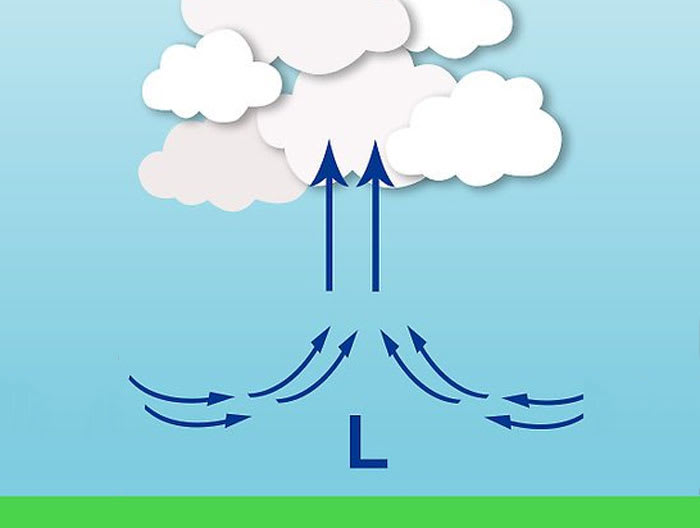
Air moves toward the low-pressure area from surrounding high-pressure zones. This inward movement is called convergence. As air converges, it rises because it cannot go down.
The rising air cools and condenses, creating clouds and rain. The wind in a low-pressure system often spirals due to the earth’s rotation. In the Northern Hemisphere, it moves counterclockwise; in the Southern Hemisphere, clockwise.
This circulation causes air to rise and moisture to build, signaling the presence of air in a low-pressure system. Understanding this movement helps identify weather patterns and predict storms.
Credit: pilotinstitute.com
Identifying Air In Low-pressure Systems
Identifying air in a low-pressure system is key to understanding weather changes. Low-pressure areas often bring shifts in weather, such as storms or rain. Observing several signs can help detect the presence of air in these systems. These signs include pressure patterns, wind behavior, clouds, and temperature shifts. Each factor offers clues about the air movement and weather conditions within a low-pressure zone.
Pressure Drop Patterns
Pressure in a low-pressure system drops steadily as air rises. The drop is not random but follows a clear pattern. A rapid decrease in pressure often means strong air movement. Slow or irregular drops might indicate weak or shifting air. Tracking these changes helps predict how the system will develop.
Wind Direction And Speed
Winds in low-pressure systems usually move toward the center. This inward flow causes air to rise and cool. Wind speed increases as the pressure drops. Changes in wind direction often signal shifts in the air mass. Monitoring wind helps understand the system’s strength and path.
Cloud Formations
Clouds form as air rises and cools in low-pressure areas. Thick, dense clouds often appear, signaling moist air. Types like cumulus and nimbostratus are common. These clouds can bring rain or storms. Cloud shape and movement reveal air stability and moisture levels.
Temperature Changes
Temperature usually falls in a low-pressure system due to rising air. Warm air rises and cools at higher altitudes. Sudden temperature drops can show incoming cooler air. Temperature shifts help track fronts and weather changes. These changes affect comfort and safety outdoors.
Key Signs Of Air Movement
Air movement plays a crucial role in low-pressure systems. It affects weather patterns and helps predict storms. Recognizing key signs of air movement can improve weather understanding. These signs include rising air, changes in humidity, and precipitation signals. Each sign reveals important information about the air’s behavior in a low-pressure area.
Rising Air Indicators
In low-pressure systems, air tends to rise. This rising air cools and expands as it moves upward. It often causes clouds to form. Look for:
- Clouds growing taller and thicker.
- Wind that feels stronger and shifts direction.
- Cooler temperatures near the ground as warm air lifts.
These signs suggest air is moving upward, a key trait of low-pressure zones.
Humidity And Moisture Levels
Rising air carries moisture from the surface. This raises humidity in the surrounding air. Watch for:
- Increased dampness or stickiness in the air.
- Visible mist or fog forming close to the ground.
- Clouds with higher water content, appearing darker or thicker.
High humidity signals that air is lifting and holding more moisture.
Precipitation Signals
Rising moist air often leads to precipitation. Rain, snow, or drizzle can start as the air cools. Notice:
- Dark clouds gathering, especially cumulonimbus or nimbostratus types.
- Light rain or snow beginning after cloud buildup.
- Sudden changes in wind speed or direction before precipitation starts.
These signs confirm active air movement and moisture in a low-pressure system.

Credit: quizlet.com
Tools For Detection
Detecting air in a low-pressure system requires precise tools. These instruments measure key factors like pressure, wind speed, and atmospheric changes. Accurate detection helps predict weather shifts and understand air movements. Below are essential tools used by meteorologists and weather enthusiasts alike.
Barometers
Barometers measure atmospheric pressure. Low pressure indicates rising air and stormy weather. A falling barometer reading signals air lifting in the system. Simple mercury or aneroid barometers show these changes clearly. Digital barometers offer real-time data and easy tracking.
Anemometers
Anemometers measure wind speed and direction. Wind patterns reveal air movement within low-pressure areas. Strong, swirling winds often accompany these systems. This tool helps identify how air circulates and where it flows. Cup and vane anemometers are common types used worldwide.
Weather Radar
Weather radar detects rain, clouds, and air moisture. It shows areas of rising warm air typical in low-pressure zones. Radar images help spot storms forming due to air lifting. Doppler radar also tracks wind velocity inside these systems. This tool provides detailed, visual data for weather analysis.
Impacts Of Air In Low-pressure Systems
Air trapped in a low-pressure system causes irregular pressure readings and fluctuating performance. Signs include unusual pressure drops and inconsistent system operation. Detecting air early helps maintain system efficiency and prevents damage.
Air in low-pressure systems can have significant effects on the surrounding environment. The presence of air in low-pressure areas can lead to various changes in weather patterns and storm development. Understanding these impacts is crucial for predicting and preparing for severe weather events.Weather Changes
Low-pressure systems with air can cause changes in weather conditions, including increased cloud cover, precipitation, and wind speeds. Warm air rises and cools, resulting in the formation of clouds and precipitation. The amount and intensity of precipitation can vary depending on the amount of air present in the system.Storm Development
Air in low-pressure systems can contribute to the development of storms. As warm air rises, it creates an area of low pressure near the ground. This low-pressure area pulls in more air from surrounding areas, which can lead to the formation of storms. The presence of air in the system can also lead to the formation of thunderstorms, heavy precipitation, and strong winds.Effects On Local Climate
The presence of air in low-pressure systems can have a significant impact on local climate conditions. Changes in temperature and humidity levels can occur, leading to variations in precipitation patterns and weather extremes. In some cases, the presence of air in low-pressure systems can lead to a cooling effect, resulting in cooler temperatures and increased precipitation.
Credit: scijinks.gov
Frequently Asked Questions
What Does Air Movement Indicate In A Low-pressure System?
Air movement in a low-pressure system indicates rising air. This rising air causes clouds and precipitation. It signals unstable weather and often leads to storms or rain.
How Is Air Direction Related To Low-pressure Systems?
Air flows inward toward a low-pressure system. This inward movement causes air to rise. It results in cloud formation and often precipitation.
Why Does Low Pressure Cause Cloudy Weather?
Low pressure causes air to rise and cool. Cooling air condenses water vapor into clouds. This process often leads to rain or storms.
What Are Common Signs Of Air In A Low-pressure System?
Common signs include inward air flow, rising motion, and cloud formation. These signs indicate unstable weather conditions. They often bring rain or storms.
Conclusion
Air in a low-pressure system often shows clear signs. It usually causes rising air and cloud formation. This leads to cooler temperatures and possible rain. Winds tend to move toward the low-pressure area. Watching these signs helps predict weather changes.
Understanding these clues is useful for daily planning. Stay aware of how air behaves in these systems. It makes weather easier to understand and follow.